
")
")
")
Geocoding Item physical location

Basically, the best way to find something is to know its precise coordinates. Here we think about how to technically store such data in the various media produced around the item, and its potential security concerns. Depending on the file type, this data may be technically stored within the document "as it", in specific universal fields like EXIF standards for images, or in encrypted custom fields.
Exhibited Assets
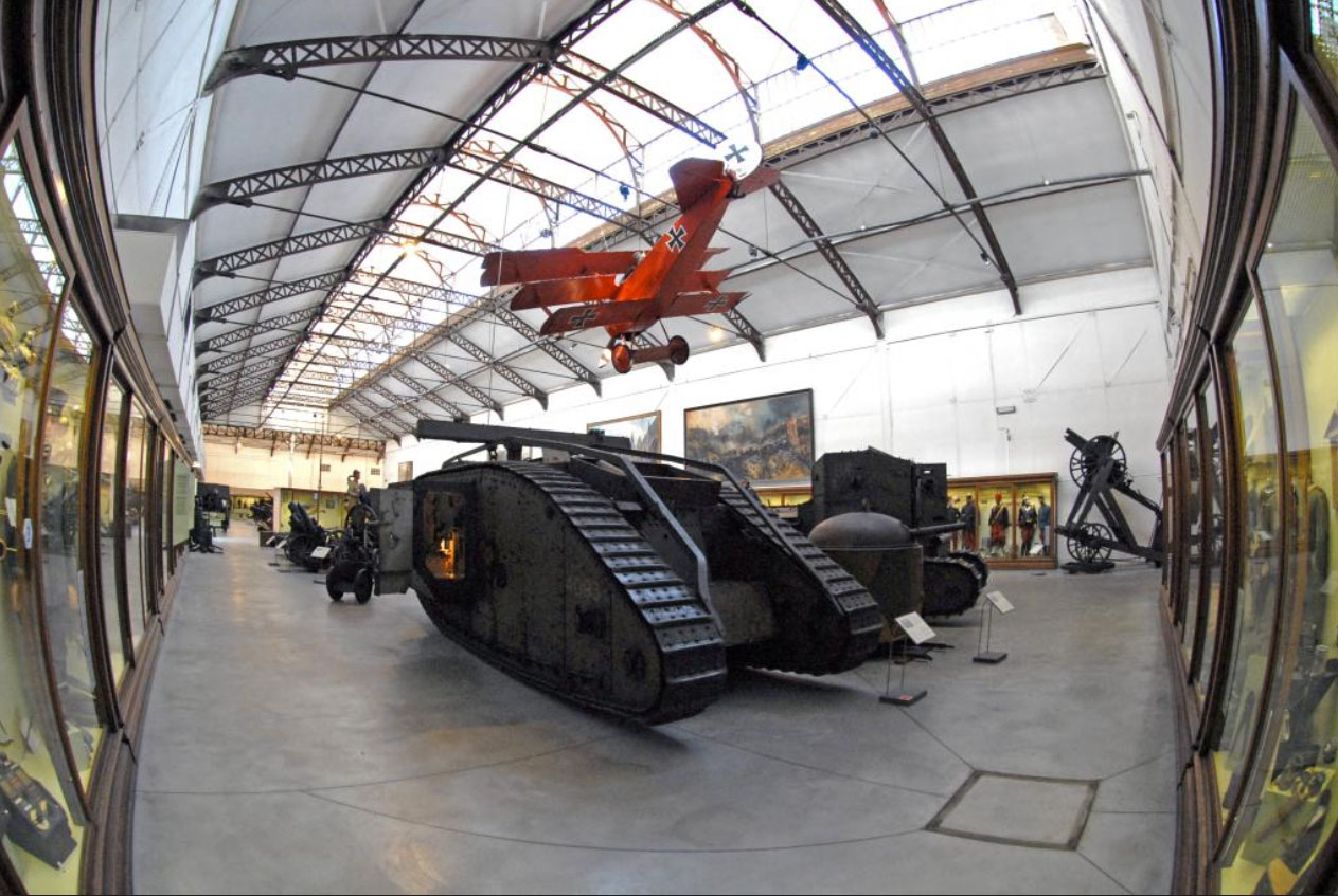
In the example of the Mark IV Lodestar III tank, of the War Heritage Institute museum in JubelPark, Brussels, the asset is exhibited in 14-18 WW1 public showroom, so everybody knows where it is.
- The actual Exact Coordinates of the Asset are : 50°50'28.91" N 4°23'37.82" E.
- Fun Fact the Faraday Cage produced by the metallic marquise of the Museum Architecture produce phone signal jamming slightly moving the coordinates to 50°50'29.61" N 4°23'35.81" E, thus every picture taken by the general public is slightly wrong, but not enough to fool the AI search systems of the Google Photos or Apple Maps which automatically associate coordinates with the nearest probable establishment, allowing people to somehow find things with acceptable accuracy.
- However, an issue to Digitization crews, it evens blocks the signal to less sensitive devices so for example DJI Mavic Pro 2 cannot reach GPS satellite during shooting operations, forcing digital assets managers to re-inject it in post-production of consolidated media banking.
Here, we have 3 layers of Location Management :
- Absolute Coordinates: Latitude, Longitude on Planet Earth, Europe, Belgium, Brussels
- Civilian Coordinates: War Heritage Museum, Parc du Cinquantenaire 3 - 1000 Brussels, Belgium (which can be deduced from GPS coordinates)
- Relative Coordinates: War Heritage Institute, Vehicle Collections, Brussels Exhibition showroom, WW1 1914-1918 Room, East wing. (which mix factual location and internal storage management policy, therefore cannot be deduced from GPS coordinates)
On top of that, the media itself may not refer to the entire item body but only a sublocation. We already encountered this topic during the workshop session with Robby Houben on April 20th 2021 and concluded an item universal positioning system would be appropriate in addition to Global Positioning Systems as the Medical industry already figured in human body while building the Dicom Metadata standards.
NON-EXHIBITABLE ASSETS
There are many reasons not to display an item, some obvious:
- the item is actually in repair or maintenance in another location than its usual storage
- the item has not been selected to be part of any current exhibition so it's in the warehousing facilities
- the item has been temporarily sent to another museum for an event display
- the item is currently being moved from a place to another
- the item is immaterial, by essence in motion, or ubiquitous*
...and some more specific:
- the item is threatened by thievery and the exact location must be hidden from the public eye
- the item is of strategic importance and may cause a national security threat if revealed
- the item is threatening people's health with no adequate preparation
In 2021, the Insitute of Marine Biology Globice director, Jean-Marc GANCILLE, in Reunion Island mentioned in an interview to our crew the threat to wildlife animals such as Cetaceans while media managing. In fact, sharing the sighting of "desirable" specimens with coordinates may put it at risk (Endangered Sea Turtles are by nature curious and tend to approach humans to take a closer look at them...) or put the general public itself at risk (sperm whale are heavily hunted by amateur sea photographers but can cause severe injuries if not death threats...). The point is, a single photo shared with a smartphone from the ship's bridge on social media here acts as an instant magnet for public attention, as GPS coordinates are directly and easily accessible to the public audience.
In another Museum Institution, the Cité du Volcan in the same Reunion Island, the director Patrice HUET explains how in his specific geological field, data has to be explained to avoid mass hysteria. Here, the museum is capturing and displaying live data from captors around the patrimonial object, the active volcano La Fournaise. Before and between each eruption, small earthquakes, and tremors shake the land around, fumes change in chemical composition, rifts slightly move at some specific locations. There again, hiding this data outside the museum rooms is critical. Only inside the institution's walls, where clever museography and trained staff surround the audience, the information can be fully explained and misconceptions or paranoia debunked.
Manage the Location storage security assessment ISSUES
This raises the question of, somehow, "layering" the positioning storage strategy with a scalable and user-friendly accreditation level. How to achieve that in current ecosystems, without challenging the whole Digital Assets Management Software arbitrations, and subsequent explosion of maintenance complexity issues?
If we consider the basic digital file families this is what we got:
- Filetypes that natively handle GPS positioning data storage, like jpeg, psd, tiff or any other image type document that respects the EXIF metadata standard. EXIF also works for usual sound media standards like WAV or MP3, which makes it the most durable and reliable system actually in use.
- Filetypes that can handle some form of positioning data embedded in their content: even if it not totally machine-friendly, if your staff is properly trained, they should know or learn how to factually write a description panel on top of any word document, excel sheet, slides presentation or any other kind of document that may contain easily editable text in it. in fact, this is basically what motivated the first recorded library cataloging system in human history, when Callimaque of Cirène asked his crew to create tags and inventory to the great library of Alexandria in 300 B.C. and thus inventing the metadata concept.
- Filetypes that require a third-party document to store the positioning data.
- With an actual Metadata standard solution available: for video files, widely used in the TV or cinema industries, a standard sidecar metadata file type called XMP is the best approach. XMP, as an Adobe standard, also has been extended to be used with Vector Illustrator sources and Acrobat PDF ecosystems, even if they are not commonly used by the designer's community.
- Without any "non-dirty" standard available: This includes web vector files such as SVG, to CAD 3D software, but also other technical IT formats and more exotic stuff. Here is the main issue, that may require a D.A.M. software to be handled user-friendly, but raises questionable IT hygiene strategies to always keep the data linked to the asset.
After identifying the environmental context, the second question is how to handle the security assessment. Here the options are shrinking dramatically :
- Removing or deliberately Alterate the Metadata location field content for non-assessed audiences, increasing data loss risk, misconception if originals went missing or synchronization managers get confused, and/or creating more subcopies of the same asset, and volume storage resulting inconveniences
- Keeping it, but encrypted, which would be the best option, but is not natively held by most of the actual standards, which store and read the file's metadata "in clear text". In 2021, you can encrypt an entire document, but not sub-elements, unless you have formerly created custom fields for that purpose, which would immediately place your file type out of standards. This makes sense in the actual IT general tendency, where the "moto" would be resumed by the phrase "if it is heavy or complex, split it." but is the major wall to face if you think it's an easy question. And that's not the best part of it...
THE MORAL CONCERNS, THE STRATEGICAL stakes
As there is no standard for security clearance levels, each institution may come up with its own scale of values and associated constraints. On another hand, the common greater good would suggest no such thing as a totally hermetic knowledge encapsulation system should exist, just because we are talking here about heritage and human knowledge that should survive us, preferably in the longest possible term... But it is also in human nature not to be altruist without proper education, so... let's proceed in the path considering some kind of location encryption may be sometimes required within patrimonial media management... As international standards have been agreed on civil rights, border policy, or world wide web personal data storage regulations such as european RGPD, it is at least, I think, reasonable to use actual technology encryption systems that works well for cryptocurrencies such as Bitcoin to be considered as a basic framework for the sensitivity of information, hence:
- geolocation data fields anywhere in the digital world would be submitted to a standard 3 levels policy:
- 0 or missing: available to public knowledge, without limitations
- 1, sensitive material, at a local level, so reference to product ownership or distributor's vigilance may be required, according to internal or local policy
- 2, sensitive content at a global level, such as human safety or patrimonial threat, which should refer to embedded encryptions fixed by UNESCO regulations or above, and decipherable only by assessed readers in a way that can be imposed to any IT hardware and software worldwide
I do not think this is actually possible without active concerted efforts and lobbying at international levels, but the question is worthit to be asked, and in between patrimonial actors may work on the topic more often in order to support necessary improvements and best practices. Nevertheless, it is of strategic importance even for states and nations, so the topic must grow awareness in the not-so-distant future as publications like Digital Communications and Networks are already suggesting. On top of that it is of critical importance for countries that rely on patrimonial assets as a major source of revenue, or a contrario that are threatened by belligerent neighbours because of strategic patrimonial resources, for which destruction may cause durable damage to civilian society cohesion like Bâmiyân buddhas destruction in Afghanistan in 2001.
To end the loop on this topic for today, you may try and see how our first example, the Historical War Museum of Brussels, housing many assets from major conflicts of the 20th century and some of them still effective, is already considered a sensitive location and therefore blurred when general public hit the "satellite view button".
This debate sure will be an exciting story to follow.
- Created on .
- Last updated on .